©REUTERS/Remo Casilli
Pre-reading questions:
- What comes to mind when you think about ancient Rome and its historical artifacts?
- What aspects of ancient history or archaeology intrigue you the most?
Vocabulary:
- official /uh-FISH-uhl/
- mayor /MEY-er/
- express /ik-SPRES/
- detailed /dih-TEYLD/
- fall apart /fawl uh-PAHRT/
[adjective] – agreed to or arranged by people in positions of authority
The city council announced the official opening of the new public park.
[noun] – a person who is elected or chosen to lead the group who governs a town or city
The mayor announced new initiatives for community development during the town hall meeting.
[verb] – to communicate what you think or feel, by speaking or writing, or in some other way
The artist used vibrant colors to express her emotions and convey a sense of joy in her painting.
[adjective] – giving a lot of information with many details
The detective provided a detailed account of the crime scene, including specific observations and intricate findings.
[phrasal verb] – to break into pieces
The old book began to fall apart, its pages coming loose and bindings deteriorating over time.
Article reading:
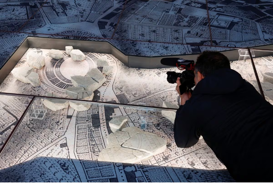
The Forma Urbis is a detailed marble map made between 203 and 211 AD during the time of Emperor Septimius Severus. It is a large map, about 18 by 13 meters, showing the layout of ancient Rome. Even though it slowly fell apart over time, about 10% of the map has survived, including parts showing the Colosseum and Circus Maximus. These surviving pieces, not shown together since 1924, are now in the museum, displayed on a copy of an 18th-century map of Rome by Giovanni Battista Nolli. This new setup helps people understand how ancient Rome was organized and its connection to the developing Renaissance city. The open-air park around the museum, on Caelian Hill, adds to Rome’s efforts to improve the area, connecting important historic sites like the Imperial Forums, Roman Forum, Colosseum, and the Appia Antica region.
Comprehension questions
- Where is the Museum of the Forma Urbis located, and what is its connection to the Colosseum?
- What is the goal of the project, as highlighted by Rome Mayor Roberto Gualtieri during the opening?
- When was the Forma Urbis marble map made, and who was the emperor at that time?
- How large is the Forma Urbis map, and what does it show?
- How much of the original Forma Urbis map has survived, and what parts are included?
Discussion questions
- Have you ever been to a museum or historical place that helped you understand how a city has changed over time? If yes, how did this experience make you appreciate the city’s history and buildings more? If not, can you imagine how exploring a detailed map like the Forma Urbis might change your view of ancient Rome and how it was laid out?
- When you learn about historical cities, do pictures like maps or models make it easier for you to understand how the city is organized and how it developed? How do these pictures help you understand history better?
- Do you think connecting a city’s streets with its museums, like Rome Mayor Roberto Gualtieri suggests, makes the city more interesting for tourists?
- Thinking about the educational value of the Forma Urbis and the open-air park, how could these projects affect local school programs? How can old places teach us important things about a city’s history?
- As Rome fixes up its old places, how can the city keep a balance between saving historical sites and making room for new buildings? What things should they think about to make sure new developments respect the city’s history?