©Denis Gliksman via BBC.com
Pre-reading questions:
I will read each question. Then, please answer them.
- Are you interested in history? Why or why not?
- What do you know about prehistoric people?
Vocabulary:
I will read the words, meanings, and sample sentences. Then, repeat after me.
- excavate /EKS-kuh-veyt/
- throughout /throo-OUT/
- accurate /AK-yer-it/
- significant /sig-NIF-i-kuhnt/
- geographical /jee-uh-GRAF-i-kuhl/
[verb] – to remove earth that is covering very old objects buried in the ground to discover things about the past
The tools were excavated in an area 400 meters from the previous site.
[adverb] – in every part, or during the whole period of time
You can see the detailed patterns throughout the walls of the palace.
[adjective] – correct, exact, and without any mistakes
I hereby certify that the above information is true and accurate.
[adjective] – important or noticeable
There is a significant increase in his salary after his promotion.
[adjective] – relating to geography, or to the geography of a particular area or place
It shows the geographical features of all the countries in the world.
Article reading:
Please read the whole article. Then, I will check your pronunciation and intonation.
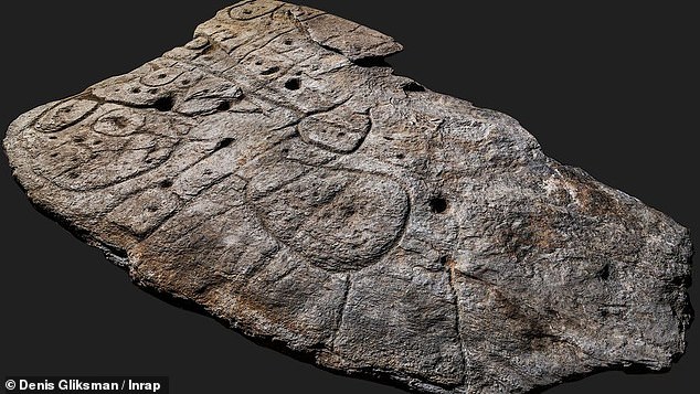
An excavated giant slab with patterns and carvings dating back from the Bronze Age may be the oldest map in Europe according to researchers. The slab known as the Saint-Bélec Slab measures 2 meters by 1.5 meters. It was first uncovered in 1900 by an archeologist named Paul du Chatellier in a prehistoric burial ground. It was found again in 2014 in a castle in France after over a century of it being almost forgotten after moving to different locations throughout the country. After analyzing the markings, the researchers thought that this could possibly be a map. In a study published by the Bulletin of the French Prehistoric Society, the lines and motifs illustrate a region of Finistère in France.
Dr. Clément Nicolas of Bournemouth University, one of the study’s authors, said that the slab may be the oldest map of a location that has been identified. The marks and lines represent the River Odet valley and its river network. Geo-location revealed that the 3D map is 80% accurate . Nicolas mentioned that this is the first time a map has represented an area on a specific scale. He added that this discovery is significant because it highlights the early geographical knowledge of prehistoric people.
Dr. Clément Nicolas of Bournemouth University, one of the study’s authors, said that the slab may be the oldest map of a location that has been identified. The marks and lines represent the River Odet valley and its river network. Geo-location revealed that the 3D map is 80% accurate . Nicolas mentioned that this is the first time a map has represented an area on a specific scale. He added that this discovery is significant because it highlights the early geographical knowledge of prehistoric people.
Comprehension questions
I will read each question. Then, please answer them based on the article.
- How big is the excavated giant slab?
- Who discovered the prehistoric map?
- Why was the giant slab almost forgotten after it being discovered by the archeologists?
- What do the patterns in the slab represent?
- Why is the discovery important according to Dr. Clément Nicolas?
Discussion questions
I will read each question. Then, please answer them.
- How should the government protect discoveries like the Saint-Bélec Slab?
- Do you think that there are maps older than the Saint-Bélec Slab that could be discovered in the future? Why or why not?
- What is the importance of learning about the history? Please explain your answer.
- What do you think is the most important historical discovery in the last 20 years?
- How do we benefit from studying history?