©Denis Gliksman via BBC.com
Pre-reading questions:
I will read each question. Then, please answer them.
講師がそれぞれの質問を読むので答えましょう。
- Do you like studying history?
- Do you go to museums?
Vocabulary:
I will read the words, meanings, and sample sentences. Then, repeat after me.
単語、意味、例文を読みます。講師に続いて音読しましょう。
- slab /slab/
- giant /JAHY-uhnt/
- pattern /PAT-ern/
- nearby /NEER-bahy/
- ancient /EYN-shuhnt/
[noun] – a thick, flat piece of a solid substance, such as stone, wood, metal, food, etc., that is usually square or rectangular
The children were surprised to see such a huge slab of rock.
[adjective] – extremely large
The giant statue, “Christ the Redeemer”, can be seen in Rio de Janeiro in Brazil.
[noun] – any regularly repeated arrangement, especially a design made from repeated lines, shapes, or colours on a surface
I think this cloth has a really nice pattern.
[adjective] – not far away
There is a bakery nearby the bookstore.
[adjective] – of or from a long time ago, having lasted for a very long time
Our lesson is about the ancient civilizations in Asia.
Article reading:
Please read the whole article. Then, I will check your pronunciation and intonation.
記事を音読しましょう。講師はあなたの発音とイントネーションを確認します。
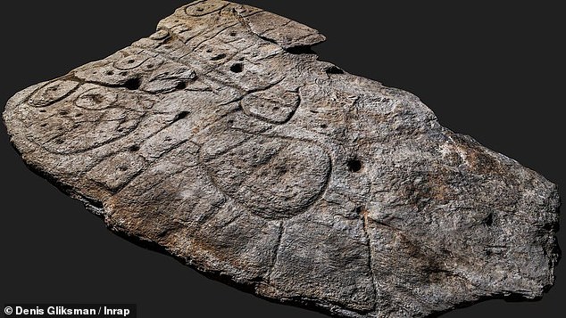
A group of scientists discovered a giant slab with patterns that date back around 4,000 years ago during the Bronze Age. This giant piece of rock called the Saint-Bélec Slab measures 2 meters by 1.5 meters. It was first uncovered in 1900 by Paul du Chatellier in a prehistoric burial ground. After analyzing the marks, the scientists thought that the slab could be a map. The patterns in this 3d map represent the River Odet valley and its nearby rivers. The Geo-location showed that it is 80% correct. One of the study’s authors, Dr. Clément Nicolas of Bournemouth University, said that this might be the oldest discovered map in history. He added that this discovery is important because it highlights the early knowledge of ancient people.
True or False:
Read the sentences and identify if they are true or false based on the article.
文章を読んで、記事に基づいて正誤を答えましょう。
- The giant slab is from the Bronze Age.
- The slab measures 2 meters by 1.5 meters.
- It was discovered by Paul du Chatellier.
- Geo-location showed that the 3D map is 60% accurate.
- The patterns and markings in the discovered slab represent the River Odet valley and surrounding rivers.
Fill in the blanks:
Choose the correct word from the table then fill in the blanks.
適切な言葉を選んで空欄を埋めましょう。
| slab | giant | pattern | nearby | ancient |
- The gift wrapper has cat ____________ all over.
- They temporarily placed the marble ___________ in the kitchen.
- The book contains information about ____________ animals.
- My baby cousin enjoyed looking at the ____________ fountain.
- Excuse me, is there a ____________ bookstore in this area?