©Denis Gliksman via BBC.com
Vocabulary:
I will read the words, meanings, and sample sentences. Then, repeat after me.
- engraving /en-GREY-ving/
- dig /dig/
- depict /dih-PIKT/
- indentation /in-den-TEY-shuhn/
- cartographic /kahr-tuh-GRA-fuhk/
[noun] – the process or art of cutting or carving a design on a hard surface, especially to make a print
The museum showcased a gallery of stone engravings from the prehistoric era.
[noun] – the process of carefully removing soil and objects from an area of historical interest
The Bronze age tools were discovered during a dig in this area.
[verb] – to represent or show something in a picture or story
His artworks depict the lives of ordinary people in the rural areas.
[noun] – a hole or mark on the surface of something
The philtrum is the indentation between the upper lip and the nose.
[adjective] – relating to the making or drawing of maps
Mr. Tranh’s cartographic knowledge is impressive.
Article reading:
Please read the whole article. Then, I will check your pronunciation and intonation.
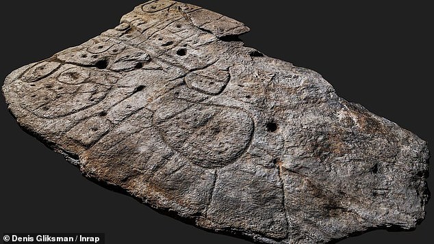
An unearthed giant slab with engravings dating back from the Bronze Age may be the oldest map in Europe according to researchers. The 2 by 1.5 meter slab known as Saint-Bélec Slab, was first uncovered in 1900 by local archeologist Paul du Chatellier during digs on a prehistoric burial ground. It was found again in 2014 in a cellar in a castle in France after the slab was apparently forgotten for more than a century as it was moved to different locations throughout France. After examining the patterns, the researchers speculated that the slab could be a map. According to a study published in the Bulletin of the French Prehistoric Society, the “presence of repeated motifs joined by lines” on its surface indicated that it depicted a region of Finistère in France.
One of the study’s authors, Dr. Clément Nicolas of Bournemouth University, said that the slab could possibly be the oldest map of a territory that has been identified. The indentations and lines represent the River Odet valley and its river network. Geo-location showed that the area around an 18 mile-long stretch of the river depicted in the 3-dimensional map is 80% accurate. The map may have been used to mark a specific location, according to Dr. Nicolas. “There are several such maps carved in stone all over the world. Generally, they are just interpretations. But this is the first time a map has depicted an area on a specific scale,” Nicolas said. He added that this discovery is important as it highlights early cartographic knowledge of past societies.
One of the study’s authors, Dr. Clément Nicolas of Bournemouth University, said that the slab could possibly be the oldest map of a territory that has been identified. The indentations and lines represent the River Odet valley and its river network. Geo-location showed that the area around an 18 mile-long stretch of the river depicted in the 3-dimensional map is 80% accurate. The map may have been used to mark a specific location, according to Dr. Nicolas. “There are several such maps carved in stone all over the world. Generally, they are just interpretations. But this is the first time a map has depicted an area on a specific scale,” Nicolas said. He added that this discovery is important as it highlights early cartographic knowledge of past societies.
Discussion Questions:
I will read each question. Then, please answer them.
- What can you say about the early geographical knowledge of prehistoric people?
- What is the significance of this discovery?
- What images come to your mind when you hear the word “prehistoric”?
- What do you know about the ancient history of your country?
- What do you want the future generations to know about the life of humans today?
Summarization
Please summarize the whole article using your own words and expressions. You will have one minute to prepare before you answer.
Describe:
Please explain the definition of each word listed below based on your understanding. You can provide example sentences if needed.
- slab
- archeologist
- prehistoric
- territory
- society