© Consulate of the Kingdom of Tonga
Vocabulary:
I will read the words, meanings, and sample sentences. Then, repeat after me.
- depict /dih-PIKT/
- blanket /BLANG-kit/
- debris /duh-BREE/
- aftermath /AF-ter-math/
- tarmac /TAHR-mak/
[verb] – to represent or show something in a picture or story
The images released by the media depict the impact of the recent volcanic eruption.
[verb] – to cover something completely with a thick layer
The ocean’s visibility is poor. It’s blanketed by a thick mist.
[noun] – broken or torn pieces of something larger
The satellite spotted potential debris from the missing plane.
[noun] – the period that follows an unpleasant event or accident, and the effects that it causes
Many repairs have been done in the aftermath of the earthquake.
[noun] – an area of ground covered with a hard surface, especially the areas of an airport where aircraft park, land, and take off
The planes on the tarmac are ready for takeoff.
Article reading:
Please read the whole article. Then, I will check your pronunciation and intonation.
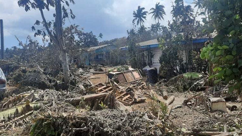
Tonga’s consulate in the European Union (EU) has disclosed pictures that show the damage dealt by tsunami waves triggered by the Hunga-Tonga-Hunga-Ha’apai undersea volcano eruption on Saturday, January 15. The released images depict volcanic ash blanketing the Pacific islands, including cars, roads, and buildings in the capital Nuku’alofa. They also show debris across the shoreline on the coastal areas on the islands in the aftermath of the disaster. Meanwhile, aerial photographs captured by the New Zealand Air Force reveal that some villages on yet-to-be-reached islands have been wiped out. Reports say that international phone lines have been restored, but repairing a destroyed underwater cable might take weeks. As of now, Tonga is largely cut off from the rest of the world, with little known information on the extent of the damage.
According to a news report agency, efforts to clear heavy ash from Tonga’s major airport runway ended on Wednesday, January 19, after rescue personnel and hundreds of volunteers worked tirelessly to sweep dust off the tarmac with wheelbarrows and shovels. The tsunami had recorded waves of 1.2 meters (about 4 feet) around Nuku’alofa City, flooding coastal roads and properties. Tsunami warnings were issued in Fiji, Samoa, Vanuatu, some portions of New Zealand, Japan, Peru, the United States, and Canada (British Columbia). Experts believe that the eruption of an underwater volcano near Tonga was likely the largest recorded in more than 30 years anywhere on the planet.
According to a news report agency, efforts to clear heavy ash from Tonga’s major airport runway ended on Wednesday, January 19, after rescue personnel and hundreds of volunteers worked tirelessly to sweep dust off the tarmac with wheelbarrows and shovels. The tsunami had recorded waves of 1.2 meters (about 4 feet) around Nuku’alofa City, flooding coastal roads and properties. Tsunami warnings were issued in Fiji, Samoa, Vanuatu, some portions of New Zealand, Japan, Peru, the United States, and Canada (British Columbia). Experts believe that the eruption of an underwater volcano near Tonga was likely the largest recorded in more than 30 years anywhere on the planet.
Discussion Questions:
I will read each question. Then, please answer them.
- Which place in your country is prone to tsunami attacks? Please tell me more about it.
- How do you know that a tsunami is going to hit soon? Does the area you live in have an early warning system?
- If you were a resident of Tonga affected by the tsunami, what would you do?
- Do you agree that the destroyed underwater cable will take weeks to be repaired?
- How do you think rescue teams should contact Tonga?
Summarization
Please summarize the whole article using your own words and expressions. You will have one minute to prepare before you answer.
Describe:
Please explain the definition of each word listed below based on your understanding. You can provide example sentences if needed.
- disclose
- shoreline
- aerial
- wipe out
- runway