©REUTERS/Remo Casilli
Vocabulary:
- influx /IN-fluhks/
- reign /reyn/
- layout /LEY-out/
- innovative /IN-uh-vey-tiv/
- facilitate /fuh-SIL-i-teyt/
[noun] – the fact of a large number of people or things arriving at the same time
The company faced challenges managing the unexpected influx of orders during the holiday season.
[noun] – the period of time when a king or queen rules a country
Queen Victoria’s reign in the 19th century witnessed significant social and industrial transformations in Britain.
[noun] – the way that something is arranged
The architect carefully considered the layout of the museum to ensure an engaging and seamless experience for visitors.
[adjective] – using new methods or ideas
The company introduced innovative technology to streamline its operations and improve efficiency.
[verb] – to make something possible or easier
The new software was developed to facilitate communication between team members working remotely, enhancing collaboration and productivity.
Article reading:
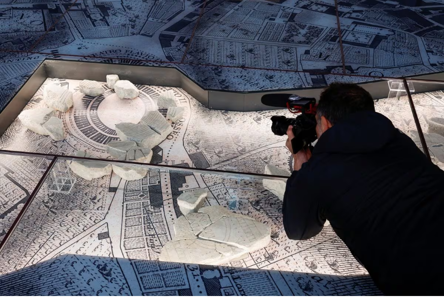
The Forma Urbis, a meticulously detailed marble map crafted between 203 and 211 AD during the reign of Emperor Septimius Severus, spans 18 by 13 meters, intricately showcasing the layout of ancient Rome. Despite its gradual disintegration over time, approximately 10% of the map has been preserved, featuring key sections such as the Colosseum and Circus Maximus. These fragments, not collectively displayed since 1924, now find their place in the museum, presented on a reproduction of an 18th-century map of Rome by Giovanni Battista Nolli. This innovative setting serves not only to facilitate an understanding of the ancient city’s layout but also offers valuable insights into its relation to the evolving Renaissance city. The open-air park surrounding the museum, located on the Caelian Hill, is adorned with walkways featuring ancient Roman grave markers and marble columns, making a significant contribution to Rome’s ongoing refurbishment efforts. The 5-million-euro project breathes new life into the Caelian Hill, establishing it as a key cultural hub that ties together historic areas such as the Imperial Forums, Roman Forum, Colosseum, and the Appia Antica region.
Discussion Questions:
- Have you ever visited a museum or historical site that provided you with a deeper understanding of a city’s historical evolution? If so, how did that experience enhance your appreciation for the city’s history and architecture? If not, can you imagine how exploring a detailed map like the Forma Urbis might impact your perception of ancient Rome and its layout?
- When learning about historical cities, do you find that visual aids, such as maps or replicas, help you grasp the layout and development of the city more effectively? How do these aids or tools contribute to your understanding of history?
- Do you agree with the idea that linking a city’s streets with its museums, as emphasized by Rome Mayor Roberto Gualtieri, enhances the overall appeal to tourists?
- Considering the educational value of the Forma Urbis and the open-air park, how might these initiatives influence local educational programs and initiatives? In what ways can historical sites contribute to a city’s educational landscape?
- As Rome undergoes refurbishment efforts, how can the city strike a balance between preserving its historical sites and allowing for modern development? What criteria should be considered to ensure that development respects the city’s historical integrity?
Summarization
Describe:
- aesthetic
- archaeological
- disintegration
- inauguration
- refurbishment